France’s 40-day continuous rain record concluded on Monday, although flooding remains a concern even as certain regions begin to show some recovery, according to the national meteorological agency Météo-France, which reported this on Tuesday.
The former record for consecutive days of rainfall was established in 2023, with rain occurring continuously for 32 days.
This year, the continuous period extended from January 14 until February 22, marking the longest rainfall sequence ever documented in the country since records started in 1959, as reported by the agency.
Météo-France considers a “rainy day” to be any 24-hour period where the average overall precipitation in a particular region, or nationwide, reaches or exceeds 1 millimeter. On Monday, the total dropped to 0.7 mm, thereby ending the streak.
This buildup of precipitation is associated with a sequence of disturbances and recent storms, including Goretti, Ingrid, Nils, and Pedro, along the Atlantic, bounded by two anticyclones located over Africa and northern Europe. Climate change also has a tendency to increase rainfall.
“A warmer atmosphere holds more moisture, increasing the likelihood of heavy rainfall, while also changing when it occurs,” says Météo-France.
Starting from 1 January, the amount of rain that typically falls during an entire winter, or even more, has been recorded at the tip of Brittany, a significant portion of southwestern France, and the Mediterranean coast, with 44 rainy days, as opposed to 48 in a normal winter.
February has already seen its highest average rainfall nationwide since 1959. Additionally, the winter season of 2025-2026, which is still ongoing, is expected to be among the top 10 wettest winters since the agency was founded.
Although the weather looks better in many areas at the beginning of the week, the soil is still very wet.
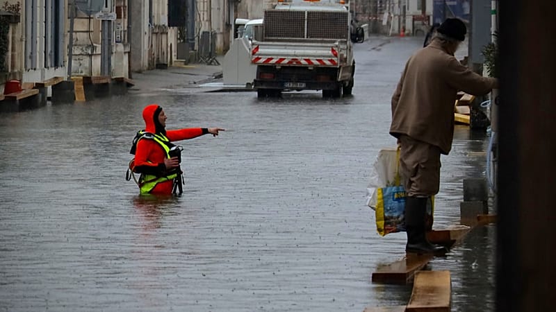
The national organization in charge of monitoring floods, Vigicrues, has stated that the water level will decrease “very gradually” even if the weather conditions improve over the next few days and weeks.
Two French regions, Charente Maritime and Maine, remain under a red alert for flooding, as stated in the bulletin released at 10:00 AM on Tuesday by Météo-France.
The Ministry of Ecological Transition mentioned in a press statement that 58 watercourses are on alert in 45 departments. These include two rivers, the Maine-et-Loire in the Angers region and the Charente in the Saintes area, which remain under a red alert, signaling “substantial flooding.”
Officials reminded the public that even regions under a yellow alert, which indicates a lower level of risk, and as of Tuesday morning, 51 rivers were categorized this way, could still overflow in certain locations, and therefore urged people to remain cautious.
Nevertheless, the water levels in the western region of the country, which have faced severe flooding for more than a week, started to gradually decrease during the weekend.
“The decline is in progress, even though it is not occurring at the same pace in all areas,” stated the ministry.
Météo-France predicts mostly dry conditions until late Thursday, with temperatures “unusually warm for this period of the year”.
Temperatures are predicted to rise to between 15 and 20°C in many parts of the country, although it has been cautioned that this relief might not last long, as additional rain is anticipated to occur from Thursday night through Friday morning.


Leave a comment