

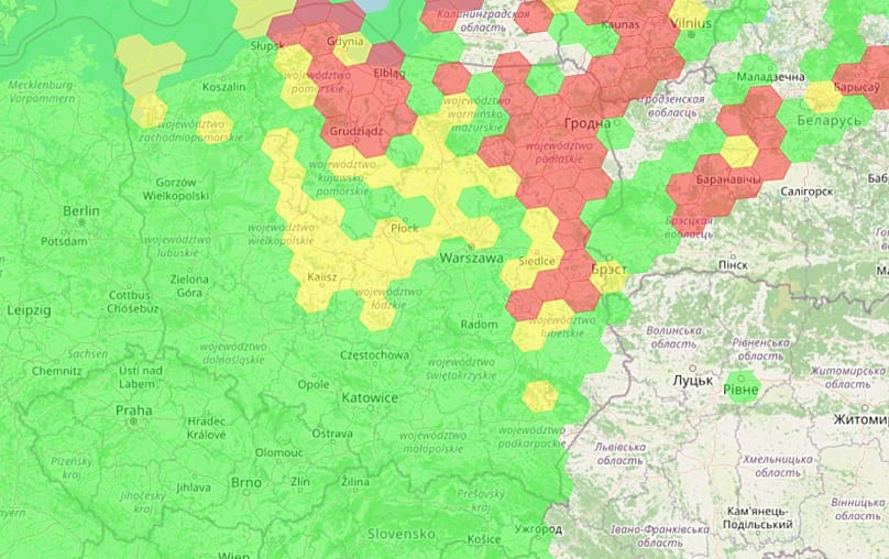
Poland has faced growing interference with satellite navigation systems, such as GPS, this summer, as reported by a monitoring station managed by Poland’s National Institute of Telecommunications.
The information, shared with the Polish Press Agency, indicated extended disruptions impacting all global navigation satellite system (GNSS) frequencies during the past few months.
Regular anomalies have been documented since January 2024, but from the start of 2026, their occurrence and strength have increased significantly.
During May and June, notable, extended disruptions across all GNSS frequency bands were observed on approximately 70% of the days. Days without any interference made up only 10% in May and 13% in June.
During the first 19 days of August, there was complete disruption on 63% of the days. This means that using smartphones and civilian receivers for navigation faced problems, on average, about two out of every three days.
Occasional disruptions, impacting one specific band, were observed on anywhere from a dozen to nearly 30% of days during the summer.
The cause
The Telecommunications Institute has stated that the origin is external and associated with the operations of electronic warfare systems in the Baltic Sea area.
Authorities emphasize that the disturbances are ongoing and will remain as long as military operations involving the sending of jamming signals take place in the region.
Comparable results have been obtained through separate measurements conducted by firms like Blue Dot Solutions.
During July 2026, stations in Pomerania experienced interruptions for nearly 90 hours, making up over 12-20% of the month, depending on the method applied. In this instance, the issue impacted the L1 band, which is crucial for civilian users.
The effects are being experienced well beyond individuals who use navigation applications on their devices, who might face incorrect location data, loss of connection, or difficulty in determining a path.
Challenges are also impacting city and shared transport systems, with the displayed locations for bicycles, scooters, or cars possibly being incorrect. Leisure and business drone flights are also facing increased difficulties, as the aircraft may experience unreliable location data, as reported by Interia news.
The disturbances are also impacting shipping and air travel, with ships facing the possibility of showing wrong positions. On August 21, the Polish minehunter ORP Albatros encountered GPS interference while conducting operations in the Baltic Sea, as confirmed by NATO’s Joint Force Command Brunssum in a post on X.
According to Interia, specialists from the Gdańsk University of Technology, the Maritime University of Gdynia, and the Institute of Telecommunications have been pointing out for months that the primary causes of interference and signal manipulation (spoofing) are situated in the Kaliningrad area.
Poland is among the nations most vulnerable to this issue, as a large portion of its land, particularly at typical flight altitudes, lies within the coverage of interference systems in the region.
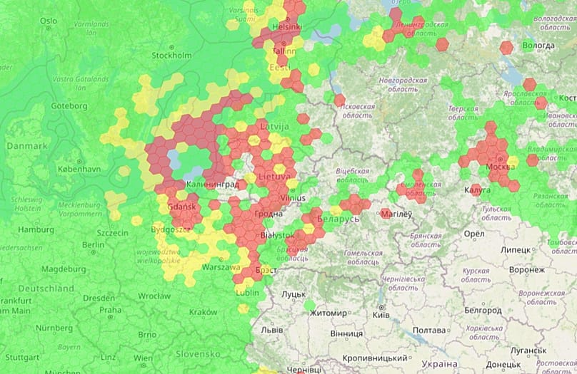
In 2026, Lithuania stated that the spoofing infrastructure in Kaliningrad had seen a substantial expansion, with the number of antennas rising from only a few at the beginning of 2025 to dozens. This is said to enable the manipulation of signals over distances of up to 450 km, potentially covering a large portion of Poland, the Baltic countries, and some areas of the Nordic region.
The Telecommunications Institute cautioned individuals against depending exclusively on their phone’s mapping applications. Instead, it is recommended that people employ conventional navigation and orientation techniques whenever feasible, or to download maps for offline access beforehand.
In the long run, Poland is establishing its own monitoring systems, such as a portal utilizing the ASG-EUPOS network and a proposed sensor network managed by the Polish Space Agency.
GPS interference in Europe
Following Russia’s large-scale invasion of Ukraine in February 2022, numerous comparable events have been documented across Europe, especially in the Baltic, Nordic, and Black Sea areas.
Western officials and specialists have consistently blamed Russia, which asserts that these actions are aimed at protecting against Ukrainian drones. However, Baltic and Nordic nations emphasize that the scope and severity of the interference extend well beyond Russian territory and constitute a deliberate provocation.
During an event in September 2025, a Spanish military aircraft transporting Spanish Defense Minister Margarita Robles experienced GPS disruption while flying close to Kaliningrad on its route to Lithuania.
The plane’s systems identified an effort to interfere with the signal, but due to military protections and auxiliary systems, the flight proceeded without significant problems.
In the same month, an aircraft transporting European Commission President Ursula von der Leyen experienced (or had significant interference with) the GPS signal while approaching Plovdiv airport in Bulgaria.
Bulgarian officials first suggested potential Russian involvement. The plane landed securely through backup systems, yet the event still triggered a discussion. Some flight-tracking information cast doubt on the extent of the signal loss, though.
A European problem
For many years, the Baltic and Nordic nations have raised concerns regarding the increasing issue of electronic interference, impacting civil aviation, maritime operations, and unmanned aerial vehicles.
Estonia, Latvia, Lithuania, Finland, and Sweden have observed a significant rise in the number of incidents, while comparable issues have also been reported near the Black Sea.
In reply, NATO has stated that it is increasing its surveillance and actions to address flight interruptions, while specialists have emphasized the importance of creating more robust navigation and tracking systems.






Leave a Reply